One week ago, Monday June 13th, we all sat in the shop watching the river flows on the USGS charts climb. As we checked in with the stream gages, the videos and photos of the river upstream started to pour in. The Yellowstone River was already raging in full force with spring run off, but now it was breaking record flows every time we refreshed the page.
We had a relatively dry winter and saw concerning snowpack levels all season. We prayed, we rain-danced, we bargained with the moisture gods to bring us some precipitation so we could have a relatively normal season on the Stone. Finally, this spring it started raining. And raining. And raining. We had weeks on end of rain making a muddy mess of everything down low but filling in the high elevation snowpacks and making our hopes for a normal season seem like something that would actually happen. Snowpack levels were now reading well over 150% for our area and we all let out a sigh of relief knowing that we would actually have water this year.
Mixed into the final days of our wet spring were warm days, hot days even. Temps in the 70s and 80s made appearances in late May and June, speeding up our runoff. Then, we had a rain on snow event caused massive blow outs on the Lamar, the Gardiner, the Yellowstone, and other smaller streams. Red Lodge, the Stillwater area, Cooke City, Silver Gate, and Gardiner were the first get hit by the raging waters.
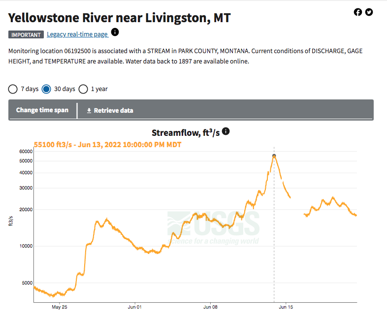
The water rose quickly and blew out it’s normal banks and took out roads, bridges, houses, sheds, and much of Red Lodge on it’s way. We watched through our phones as people posted videos of the Yellowstone taking out the Tom Miner bridge, the hundred plus year old steel structure tumbling into the water. We checked the USGS stream gage at Corwin Springs, it read over 50,000 cfs. The previous record for that location was 30,000. The river had completely overtaken Highway 89 in Yankee Jim Canyon and was wearing down the Point of Rocks bridge, making it impassable.
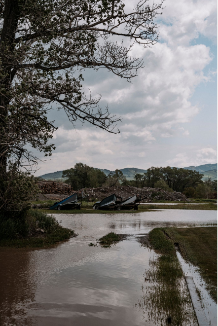
We are situated on Highway 89 South and though we aren’t directly on the river we are close. There is a lumber yard that surrounds our property and is between us and a side channel of the Yellowstone, one that hasn’t carried too much water since the last big flood. We worked to clear out cardboard boxes out of basement and kept an eye out for water in the lumber yard. The water started appearing there in the afternoon as we were scrambling to empty the basement in preparation for the water we expected we would get. By now, they had closed Highway 89 to non-emergency travel. There were helicopters and small planes flying overhead, sheriff’s deputies from neighboring counties, and just about every other law enforcement and rescue crew you could think of racing down the highway to help evacuate people and assess damage.
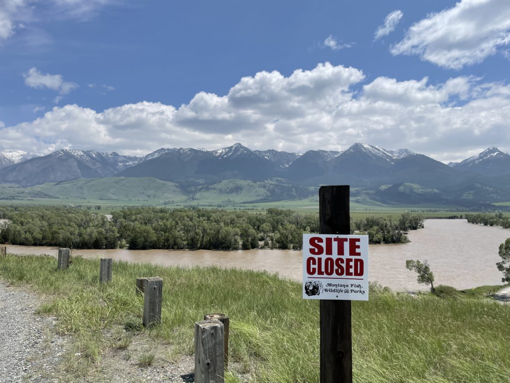
Yellowstone National Park evacuated all guests in the park and shut down all of it’s entrances, the National Forest Service closed the National Forest around us, and of course all of the fishing access sites were closed.
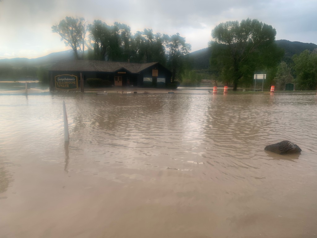
That night when we closed up shop at 5 PM, we did not have any standing water close to us. By 7:30 that night the basement had over 20″ of water with more rushing in and the shop was surrounded by knee to waist deep water. Sump pumps were running and sandbags placed and we settled in for a long night. The river was expected to peak that night, which it did at 10 PM– coming in at record breaking 55,100 CFS at Carters Bridge. The river had breached levees at Armstrong’s spring creek and in Sacajawea Park in Livingston. Parts of Livingston were evacuated and volunteers worked through the night to fill sandbags and get them to people who needed them.
The next day as water slowly receded, we were able to see the damage that had happened around us. We got lucky at the shop. Our basement somehow was the only part of the shop to flood. No water came into our main floor and there was no major damage to the building. Just south of us though others were not so lucky. The flood had reached houses on both sides of the highway, causing major damage to structures and huge losses for many. Our local animal shelter was destroyed (though they were able to evacuate all of the animals!) and more damage had been done to major roads.
Very quickly people sprung into action to help each other. From delivering clean drinking water to helping evacuate people from their homes on rafts and jet boats, the people here really stepped it up. In the following days, as we baby sat sump pumps and cleaned up debris outside, so many friends and clients stopped by or called to see if we needed help. Clients have by and large been understanding and flexible with rebooking or changing their trip plans.
Reports are calling this a 500 year flood. We will be dealing with the fallout from this for years to come, no doubt. The Yellowstone has come down significantly and now resembles the familiar spring run off we are used are to, but now we know what she is fully capable of. We still have at least a couple of weeks before the Yellowstone is fishable and when it is, we all need to be cautious of all of changes the flood has done to the river, including depositing large amounts of debris.
Yellowstone National Park’s north entrance remains closed, but the other entrances are open with restrictions. They are currently using an alternating license plate system to limit visitors. Fishing in the north eastern corner of the park may not happen this year, unfortunately as the roads leading to our favorite park fishing spots are severely damaged.
Highway 89 is now open to travel to and from Gardiner and after thorough inspections, the remaining main bridges are stable. Crews worked hard to repair the Point of Rock bridge, which just reopened. Closures are changing daily so please check in with the Department of Transportation, National Forest Service, Fish, Wildlife, and Parks, or Sheriff’s Department before traveling.
The spring creeks will be okay, the levee on Armstrong’s was able to be repaired quickly and the creeks are again running clear and normal levels. There is some new structure and lots of clean gravel in Depuy’s and Armstrong’s, but we have heard from other guides who have gone out to help assess the creeks that they did see some PMD nymphs and other aquatic life, even fish.
We really appreciate all of the support and love you all have shown us and the community the over the last week. We are still drying out and many people here have a long ways to go, but we can’t wait to get out on the water with you.
If you would like to help out with relief efforts, here is a list of organizations that are fully vetted and doing good in the community. Buying gift cards and making purchases from your favorite Livingston shops is another great way to support the small businesses here. If you aren’t local, many shops (including us!) have online stores or take orders over the phone.